


7,7 km | 10 km-effort
![Randonnée A pied Gemeinde Söll - [40] Wanderweg - Brandstadl - Photo](https://media.geolcdn.com/t/1900/400/ext.pjpeg?maxdim=2&url=https%3A%2F%2Fmedia.geolcdn.com%2Ff%2Ff5e792c0-e7a9-440a-9b2b-4120aabc3500.jpeg)

Tous les sentiers balisés d’Europe PRO


Application GPS de randonnée GRATUITE
 SityTrail
IGN / Instituts géographiques
SityTrail World
Le monde est à vous
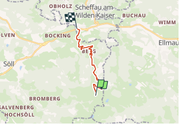
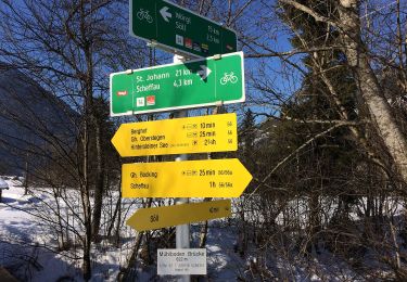
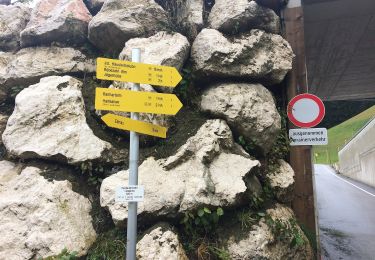
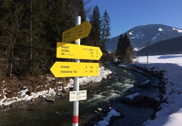
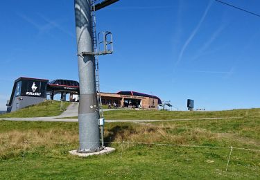
Randonnée A pied de 6,9 km à découvrir à Tyrol, Bezirk Kufstein, Gemeinde Söll. Cette randonnée est proposée par SityTrail - itinéraires balisés pédestres.
Randonnée créée par Tourismusverband Scheffau.
![Randonnée A pied Gemeinde Söll - [40] Wanderweg - Brandstadl - Photo 1](https://media.geolcdn.com/t/2048/auto/c889c77c-9822-46f9-b212-922f192e89e1.jpeg&format=jpg&maxdim=0 "Randonnée A pied Gemeinde Söll - [40] Wanderweg - Brandstadl - Photo 1")
![Randonnée A pied Gemeinde Söll - [40] Wanderweg - Brandstadl - Photo 2](https://media.geolcdn.com/t/2048/auto/8f22bd0f-60b8-4a33-8a5d-3d5572743a3b.jpeg&format=jpg&maxdim=0 "Randonnée A pied Gemeinde Söll - [40] Wanderweg - Brandstadl - Photo 2")
![Randonnée A pied Gemeinde Söll - [40] Wanderweg - Brandstadl - Photo 3](https://media.geolcdn.com/t/2048/auto/6eca6860-73f1-431a-9343-2c5416b89c88.jpeg&format=jpg&maxdim=0 "Randonnée A pied Gemeinde Söll - [40] Wanderweg - Brandstadl - Photo 3")
![Randonnée A pied Gemeinde Söll - [40] Wanderweg - Brandstadl - Photo 4](https://media.geolcdn.com/t/2048/auto/44f5eae1-f13b-4952-88fc-aab17d585dc0.jpeg&format=jpg&maxdim=0 "Randonnée A pied Gemeinde Söll - [40] Wanderweg - Brandstadl - Photo 4")
![Randonnée A pied Gemeinde Söll - [40] Wanderweg - Brandstadl - Photo 5](https://media.geolcdn.com/t/2048/auto/5e2361c7-1a78-4b0e-ac70-d89603ee4bd4.jpeg&format=jpg&maxdim=0 "Randonnée A pied Gemeinde Söll - [40] Wanderweg - Brandstadl - Photo 5")
![Randonnée A pied Gemeinde Söll - [40] Wanderweg - Brandstadl - Photo 6](https://media.geolcdn.com/t/2048/auto/63703222-7807-416b-9087-6aaa1b3aebf2.jpeg&format=jpg&maxdim=0 "Randonnée A pied Gemeinde Söll - [40] Wanderweg - Brandstadl - Photo 6")
![Randonnée A pied Gemeinde Söll - [40] Wanderweg - Brandstadl - Photo 7](https://media.geolcdn.com/t/2048/auto/c2eb2763-af77-4857-bcf4-fa59f9831e2e.jpeg&format=jpg&maxdim=0 "Randonnée A pied Gemeinde Söll - [40] Wanderweg - Brandstadl - Photo 7")
![Randonnée A pied Gemeinde Söll - [40] Wanderweg - Brandstadl - Photo 8](https://media.geolcdn.com/t/2048/auto/cafb8283-8ce0-4a6e-ad6b-9ef4ae5c253e.jpeg&format=jpg&maxdim=0 "Randonnée A pied Gemeinde Söll - [40] Wanderweg - Brandstadl - Photo 8")
![Randonnée A pied Gemeinde Söll - [40] Wanderweg - Brandstadl - Photo 9](https://media.geolcdn.com/t/2048/auto/59028a5b-7d13-4156-a04f-618ce1831242.jpeg&format=jpg&maxdim=0 "Randonnée A pied Gemeinde Söll - [40] Wanderweg - Brandstadl - Photo 9")
![Randonnée A pied Gemeinde Söll - [40] Wanderweg - Brandstadl - Photo 10](https://media.geolcdn.com/t/2048/auto/f5e792c0-e7a9-440a-9b2b-4120aabc3500.jpeg&format=jpg&maxdim=0 "Randonnée A pied Gemeinde Söll - [40] Wanderweg - Brandstadl - Photo 10")
A pied
A pied
A pied
A pied
A pied
A pied
V.T.T.

Marche
Marche